About Mauritius
Where is Mauritius located?
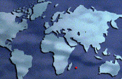
Mauritius is a small island nation, covering an area of about 1900 Km2, in the south west Indian Ocean and lies approximately 900 km east of Madagascar.

Origin
According to geologists the island emerged, million of years ago, through volcanic activities on the Mascarenes submarine plateau. These volcanic activities which lasted until about 100,000 years ago shaped the island.
The Mascarenes submarine plateau is a submerged land.
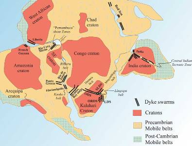
It is thought that this plateau formed part of a large continent named Gondwana (from Sanskrit gondavana - “forest of the Gonds"), by Austrian scientist Eduard Suess.

Schematic map of part of the Gondwana continent before drifting.
Map courtesy: mantleplumes.org
Gondwana had broken up million of years ago as a consequence of enormous pressure exerted by drifts in the continents.
Isolated in the Indian Ocean basin, the existence of Mauritius remained unknown to human till man started sailing the ocean and travelled to the island.
History
The Portuguese were the first Europeans to discover the island. By that time, however, its existence was already known to the Arabs.
Neither the Arabs nor the Portuguese settled here.
The Dutch were accidentally driven to its shore in 1598 and decided to colonise the island in 1638. They resentfully abandoned it in 1710 after two unsuccessful attempts to make the colony a prosperous one.
The departure of the Hollanders opened the way for the arrival of French settlers who renamed the island Île de France (literally: Isle of France.)
Île de France was impressively developed by illustrious French governor Mahé de La Bourdonnais.
Later the British engaged themselves in a battle with the French colonists to take possession of the island. Eventually, French General Decaen opted for a honourable capitulation on 3 December 1810.
The island was renamed to its former Dutch name and remained a colony of the British Empire till its independence on 12 March 1968.